![]()
![]()
A R M E N I A N
H I G H L A N D
A N I G N E O U S H O M E L A N D
MAIN SURFACE FEATURES
RA NATIONAL ACADEMY OF SCIENCES REPORT
A R M E N I A is the most mountainous of the Caucasian Republics, with an average elevation of 1,800 m above sea level. This is about twice the mean elevation of the territory of Asia. The lowest lands of Armenia are more than 400 m above sea level; that is to say that there are no lowlands in the Republic.
T H E G A T E W A Y T O E T E R N I T Y
T H E A P E X O F T H E C O S M I C M O U N T A I N --
AR
AR AT
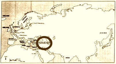
The Republic covers a small north-eastern part of the vast Armenian Highland or the Armenian Plateau which is, as it were, wedged between the mountain structures of Iran and Asia Minor, and rising some 500 m higher than either of them. That is why the Highland is called a "mountain island'. Its area exceeds 300,000 sq. km and has a mean elevation of 1,700 m.
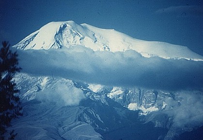
Viewed from the height of a modern jet passenger plane the Armenian Plateau shows innumerable high mountain ranges intersected by deep river valleys and hollows, plateaus and single peaks. The highest peak is Masis (Greater Ararat), the biblical giant of 5,156 meters. A vast panorama of the Armenian Plateau [Armenian Highland] with its mountain ranges cut up by valleys opens up from the top of Masis. The Plateau is almost completely enclosed by high mountains-the Pontus mountains in the north, the Lesser Caucasus range in the Northeast and East, and the Armenian (East) Taurus range in the south. The special natural features of the Highland enclosed by mountain ranges are determined by its geographical latitude, its geologic I history, the variety of its relief and the uneven heights of its absolute elevations. Its entire appearance was sharply affected by the fairly recent intensive volcanic eruptions. Academician and volcanologist A. N. Zavaritsky writes: "The relief of this country and at the same time the essential features of the climate and soil of Armenia, the distribution of the water sources on which all the country 's life depends, the minerals, primarily the remarkable materials of which the beautiful buildings of the Armenian cities are built and the very appearance of the Armenian villages, all reflect Armenia's not so distant geological past and especially the comparatively recent volcanic eruptions . " * A. N. Zavaritsky, "Some Features of Armenia's Recent Volcanism," News of the USSR Academy of Sciences, Geographical Series, No. 1, 1945.
The Armenian Highland is often called a land of extinct volcanoes, but Nemrud (west of Lake Van) is a volcano which from the geological point of view has active only the other day in 1441. The country 's high incidence of seismism and the numerous hot springs-signs of deep thermal fociare also echoes of orogenic processes and volcanism. The variety and wealth of minerals are a result of a complex geological history. Some of these minerals gold, silver and valuable building materials have been mined and processed by skillful Armenian craftsmen since time immemorial. Incidentally, W. G. Child (British archaeologist) and other researchers have established that the ancestors of the Armenians were among the world 's first tribes to mine ore, discover iron and usher in the iron age.
The Armenian Plateau was the "epicenter of the Iron Age". * S. K. Dik�it. Introduction to Archaeology, Moscow, 1960.
Over 90% of Armenian territory rises higher than 1,000 meters above sea level. The lowest lands are the valleys of the Arax and Debed rivers on the southeastern and northeastern borders of the Republic (about 400 km), while the highest point is the peak of Mt. Aragats (4,090 meters) .
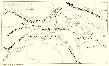
The arch of the Lesser Caucasus mountain ridges walls off the Armenian Plateau from the lowlands of Transcaucasia. But this wall is not continuous. In many places it is cut up by rivers and split by enormous clefts-gorges and canyons. The main railways and highways of the Armenia run along the valleys of the Debed, Aghstev, Vorotan, Arax and other rivers. Along these valleys humid air rises to the High Country, and from here the precipitation run down as rivers back to the lowlands of Eastern Transcaucasia.
T H E S
A C R E D
H I G H L A
N D O F
A R - M E N I A
The arched system of mountain ridges consists of two, and in the central part of three and four, rows of parallel and converging mountain chains. The central ridges of the Lesser Caucasus are composed of various sedimentary and volcanogenic Mesozoic rocks, while the outer chains are formed of Tertiary marine sediments. All these mountain systems were first bent into folds and later broken up by transverse and longitudinal faults, for which reason they now form folded and faulted structures slightly inclined to the north-east and sharply breaking towards the Highland.
The Somkhet range or Virkahaiots stretches along the Armenian-Georgian border. It dips imperceptibly towards the Tsalka upland in Georgia and drops towards the Lori Plateau in Armenia in a rather steep, short slope. Both slopes are wooded. The passes of the Somkhet range are located at an elevation of 1,700-1,800 m.
West of the Lori plateau is the higher, though smaller, Ashotsk plateau (1,800-2,000 m). Between them rises the longitudinal Javakhk volcanic range. The Ashotsk plateau is separated from Turkey by the Ghukasyan mountains which are also of volcanic origin.
South of the Ashotsk plateau stretches one of the largest and most fertile Armenian plains the Shirak plateau (1,400-1,500 m high) divided by the international boundary along the Akhuryan river.
The twin Bazum and Pambak mountain ranges stretch very nearly in a latitudinal direction south of the Lori plateau, the Pambak river running between them. These ranges are almost 3 km high and are formed of limestone and rather young volcanogenic rocks porphyrites. The northern slopes of these ranges are humid and wooded, while the southern slopes are covered with xerophilous steppe vegetation.
In the west these ranges converge, forming a low commisure - the Dzhadzor pass through which runs the way from the Pambak basin to the Shirak plateau.
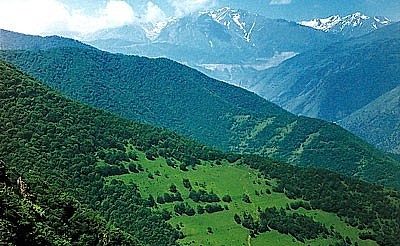
Eastward these ranges gradually diverge, the Gugarats range running north-eastwards from the Bazum range and forming a watershed between the Debed and Agstev rivers. Both the range and the valleys of these rivers are covered with a beautiful deciduous forest.
One of the spurs of the Parnbak range meets Lake Sevan where it joins with the Aregouni range which fringes the northeastern shore of the lake, while the other spur Tsakhkunyats dips south-eastwards to the wooded Marmarik valley, the site of Tsakhkadzor, Armenia's Young Children's' best health resort.
In the East of the Republic, at an elevation of almost 2 km is the Sevan hollow and Lake Sevan.
The Ararat plain, one of the largest tectonic depressions of the Armenian Plateau, stretches west of the Sevan basin, at the foothills of the Gegham mountains. In the north the plain borders on Mt. Aragats, and in the south, on the Ararat. The Arax river divides it into two. The southern part is what is today Turkey.
South of Sevan and the Vardenis mountains is the historic Syunik region which unites the Vaik and Syunik or Siwnik‛ (Zangezur) mountain regions.
On one side the Vardenis range joins through the Gandzasar mountain system with the Gegham range and in the east it merges with the small, high Alagellyar plateau. Mountain ranges diverge from it in all directions. A small range with a typical volcanic cone- Vayots Sar stretches south-westwards. Another small ridge the East Sevan runs north- eastwards. The massive Syunik range stretches south-ward and borders On the Nakhichevan . It breaks off in the wild canyon of the Arax between Meghri and Ordubad. It is one of the longest and highest rages of Transcaucasia. Its peak Kaputjukh (3,906 m) is second only to Aragats.
The other spurs-the Bargushat (between the Goris and Kafan areas) and the Meghri (between the Kafan and Meghri areas) branch off east-south-eastwards and reach an elevation of 3-3.4 km. The Siwnik‛ [Syunik] range and its spurs are composed of both young volcanogenic and intrusive, as well as older sedimentary rocks and are rich in minerals, mainly non-ferrous metals and iron.
In the north-east the Zangezur range is adjoined by the Syunik (Karabakh) volcanic upland (Mount Mets Ishkhanasar is 3,552 m high) bordering on Azerbaijan.
M O U N
T A I N
O U S
H I G H
L A N D
The Armenian Highland together with the Lesser Caucasus ridges to its north and the Armenian Taurus to its south forms a link of the vast zone of lofty mountains and uplands that cross the southern margin of the great Eurasian continent from the Pyrenees to the Indonesian Islands. The mountains of this zone were formed on the site of the ancient Tethys Ocean. The layers of the bottom of its seas can be discovered in the structure of the mountains and valleys of the present continent that has taken its place. At one time mountains formed on the bottom of the ocean as a result of orogenic, processes which gradually transformed the former ocean into land. There were a number of orogenic or tectonic processes but the most powerful of these occurred comparatively recently, during the so-called Alpine epoch of orogenesis, i. e., more than 60 million years ago.
The territory of Armenia is a geological museum where we can find samples of nearly every type of rock that forms the crust of our planet.
The oldest era Archean or Pre-Cambrian was the time when the earth crust was beginning to form. Rocks of Pre-Cambrian age-metamorphic slates, quartzite and gneiss - are found on the surface of the right bank of the upper reaches of the Hrazdan river, in the central part of the Virakhaiots range, etc. In other areas of the Republic the Pre-Cambrian foundation is either absent or lies deep under later layers (under the Ararat plain at a depth of close on 600 m). Above it are layers of the Paleozoic era the time of appearance of life on earth. For millions of years milliards upon milliards of dying protozoan formed heavy layers of limestone during this era. Paleozoic limestone occurs in the south of the Republic, in the south-western foothills of the Gegham range and south of the Vedi river to the western extremities of the Vaik range. The limestone consists of minute shells and calcite which settled chemically out of sea water. Under the enormous pressure of the overlying layers and the influence of high temperatures some of the local limestone changed to marble. Heavy layers of travertine deposited by springs which at one time issued from Paleozoic limestone, are widespread in the vicinity of the town of Ararat. They are used for the production of cement and calcium carbide.
T H E M I N E R A L W E A L T
H O F T H E A R M E N I A
N P L A T E A U
During the next Mesozoic era the bottom of the sea was compressed with the result that mighty folds and faults formed. The lava that issued solidified under the water and formed volcanogenic rocks porphyrites, tuff breccias, tuffs, etc. Part of the country's present territory in the north-east and south arose from the depths of the sea and became land, but later, towards the end of the Mesozoic era, found itself under water again and accumulated new heavy layers of limestone.
The Bazoum and Pambak ranges (in the main), as well as the Sevan range and the northeastern areas, are formed of limestone and other marine deposits of the Mesozoic age.
During the most recent Cenozoic age the greater part of the territory of the Armenia experienced powerful orogenic processes (so-called Alpine orogenesis) with the result that it took on the topographic formation that we see today.
Shallow seas or lakes persisted for some time in the lowlands, for example the Ararat hollow. They receded and evaporated, leaving clay, gypsum and common salt. Heavy layers (up to 120-130 m thick) of common salt lie under the surface of the Yerevan hollow and are mined for the alimentary needs as well as the chemical industry.
Simultaneously with the orogenesis and mainly after the solidification of the land new tectonic movements resulted in the formation of enormous, deep faults rather than folds. These movements changed and "rejuvenated" the greatly eroded and almost flat country. It was broken up by clefts and formed into powerful folds. During this folding some of the rock masses formed mountain ranges, while the lowering of other sections gave rise to areas of relative lowland (for example, the Sevan basin). This is how the present relief of the Lesser Caucasus arch formed, part of which is on the territory of the Armenia. It is characteristic that the crests of these ranges have in some places retained remnants of eroded surfaces. There are even several tiers of such leveled surfaces".
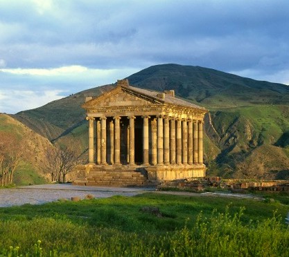
T H E T E M P L
E O F T H E S U N
G O D. M I T H R �
V M I N G A R N I.
A new cycle of volcanic activity began inside the Lesser Caucasus arch as a result of large faults, especially during the Quaternary period, the last stage of the Cenozoic age. The mountains erupted milliards of tons of molten substance and ash. Compared with the cycles of the former epochs the Quaternary period of volcanism was the most violent. Many volcanoes were still breathing fire when man made his appearance on earth. The lava filled the former hollows, covered the plains and, when it solidified, formed a hard stony armor 170-180 m and, in some places, 400 m thick. Basalt, andesites, andesite-basalts and tuffs were the rocks that predominantly formed at that time. In some areas (for example, near the village of Arzni) scientists have discovered various implements under layers of lava, traces of prehistoric settlements. This suggests that the lava is very young.
Over an extensive zone covering one-third of the Republic 's territory (from the northwestern borders to the left bank of the Vorotan river) the ancient relief is buried under young igneous rocks. Along the faults in this zone rise singly or in groups large and small volcanic cones crowned with deep craters. These are extinct volcanoes, made of intermittent layers of volcanic rocks or wholly of scoria.
The volcanic eruptions were followed by glaciation of the highest mountain ranges of Armenia. The peaks of Aragats, the Gegham, Vardenis, Zangezour and Dzhavakhet ranges were covered with a heavy coat of snow and glaciers formed in the valleys and hollows. Corries, troughs, morainic debris and ridges are some of the traces of Quaternary glaciation in Armenia. In some places these deposits are covered with lava, which suggests an alternation of volcanic eruptions and glaciations.
The solidified lava fields are now in the main covered with fertile black earth and steppe vegetation.
As the land rose the rivers cut into the rocks, deepening their beds and eroding even the hardest volcanic rocks. The canyons of the Vorotan and Debed rivers were formed in this way and now reach a depth of 400-500 m. Somewhat shallower are the valleys of the Hrazdan, Akhuryan,Dzoraget and Arpa. The slopes of the wider valleys rise in terraces.
Volcanic rock is fine building material of which tuff is one of the best. Its pink, orange, black and yellow varieties are not only used in the Republic but are also exported. There are enormous resources of igneous rocks.
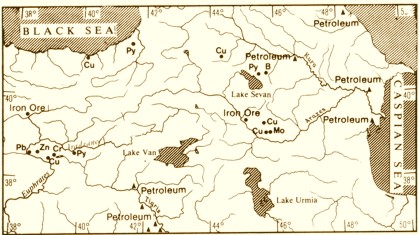
Armenia has rich deposits of copper, molybdenum, complex ores, including iron ore. Three metallogenic zones can be distinguished. * Metallogenic zones are areas rich in ore deposits as a result of superficial or deep ore-forming processes. Such zones are found in the Urals. Altai and other places.
The zone running from Alaverdi to Kafan is rich in copper pyrites. Zinc, lead, barite with an admixture of gold, and silver are also found. The Alaverdi, Shamlug and Kafan copper pyrite deposits and the Akhtala complex ore deposit are well known.
The second zone Pambak-Zangezour runs a little to the south-west of and parallel to the first. It is rich in copper-molybdenum ore deposits the largest of which are in Kajaran Agarak, Dastakert and Lichk. The first three deposits are already being exploited, and the molybdenum concentrates are sent to the country metallurgical centers for the production of a high-grade ferro-molybdenum alloy and a very strong alloyed steel.
In this zone, in the valley of the Marmarik river and in the Meghri district, there are also nepheline syenites the raw material for aluminum production.
Several iron ore deposits have been discovered in the Republic. Their total resources exceed 1,000 million tons. North of Yerevan are the Hrazdan and Kaputan deposits with ores containing 40-65 per cent metal. Apatites which can be used for superphosphate production are also found there. The largest iron ore deposit is the Svarants deposit in Siwnik' (or Zangezur -- close to 500 million tons). Its ore is self-fluxing. * Self-fluxing ores are those that contain fusing agents (limestone, silica, alumina) which in the process of smelting combine with the slag and purify the metal from harmful admixtures (for example, pig iron from phosphorus) . Among promising ferrous metal deposits are those of manganese.
I N T H E H I G H L A N D S O F S
I W N I K'
The third metallogenic zone Sevan-Amasya is known for its high-quality magnesium- chromate ores which have been discovered on the northeastern shore of Lake Sevan. Manifestations of platinum and deposits of native gold also occur there, in the East Sevan range. In some places accumulations of antimony, mercury and arsenic (realgar) are found .
New valuable substances have been discovered in the deposits of non-ferrous metals-- the rare and dispersed elements--scandium, rhenium, bismuth, selenium, tellurium, gallium, indium and thallium.
Used even in minute amounts these elements lend new properties to alloys; in their pure state they are used in various branches of up to-date complex technology.