![]()
![]()
RIVERS, LAKES, AND UNDERGROUND WATERS
Because of the dry climate the surface water run-off on the territory of the Republic is low. Of the total mass of rainfall (15,000-18,000 million cubic m a year) in the Armenia, two-thirds evaporate and only one-third enters the rivers or soaks into the rocks.
The moisture condenses and falls as rain or snow mainly in the mountains, then runs down over or under the ground and irrigates the heat-parched valleys and hollows.
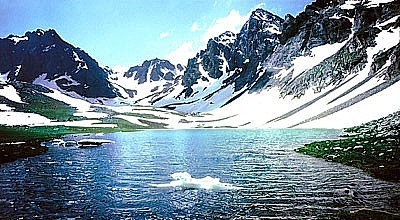
G A Z A N A L I Č L A K E
I N T H E S I W N I K' P R O V I
N C E
The peculiarities of the relief and the filtering capacity of the mountain rocks
in the different parts of the Republic unequally influence the distribution of
surface and underground waters. Owing to the porosity and fracturing of the
rocks in the volcanic areas a large part of the precipitation soaks in, forming
underground rivers and water basins and very few surface rivers, while in the
areas with a folded relief, where t-e rocks are almost impervious to water, a
surface run-off prevails.
Thus the total water resources in Armenia come from three main sources: running
waters, lakes and underground water basins. Of these, rivers alone annually
carry about 6 ,000- 7,000 million cu m of water. Rational use of these waters
could provide moisture for the droughty zone.
Armenia is covered with a dense network of rivers and streams albeit very large ones. The largest of them Aras runs along the border. More than 300 of the rivers are 10 k long or longer.
The river network is unevenly distributed. It is densest in the alpine areas. Here and in the foothills where there are level surfaces the rivers flow slowly and even meander, whereas in the mid-mountain areas they flow rapidly and possess enormous destructive power. Here the torrents have hewn picturesque giant canyons and gorges 300-400 m deep even in hard rocks basaltic strata. For example, in the Syunik Province -- the Vorotan river has cut 250-500 m deep into basalt and other hard rocks. In some places the rays of the sun do not reach the bottom of this long and narrow canyon.
The rivers of the Armenian Republic have numerous picturesque rapids, cascades and falls.
The rivers are fed by snow, rain or underground water. There are of course rivers which take their source only in springs and their run-off is naturally more regular. For example, the Metsamor (Sevjur) is fed exclusively by underground water and is one of the abundant rivers of the Republic.
The river network further breaks up the already complex relief of Armenia. Millions of tons of fertile soil are annually eroded and carried away from mountain slopes. This erosion is the bane of agriculture. especially in mountainous country where every patch of land wrested from the mountains is worth its weight in gold. The extent of the erosion is attested to by the turbidity of the rivers, which increases particularly during flood time.
In the spring the snow in the mountains melts rapidly; this is the time of
maximum rainfall and so the rivers become rapid and abound in water. The snow
does not melt simultaneously at different elevations, and the spring high flood
is therefore somewhat protracted. In the middle of summer the rivers grow
shallow, but in spring their level rises again, this time because of the rains
and not the melting of the snow. The level of the rivers is naturally lower in
autumn than in spring.
Because of their sharp gradient the rivers of Armenia move with great force and
therefore possess considerable water power resources. The total water power
resources of the rivers are estimated at 1,700,000 kW, about 40% of
which is already utilized.
The rivers of the Republic do not freeze, but they are not navigable because they are rapid, turbulent and shallow.
Most of the rivers are subject to sudden big floods, usually in the spring when they carry enormous masses of mud and stones. There are also many dry riverbeds, which fill with water only during spring snow-melting and heavy rains. Torrents of mud and stones rush down riverbeds, destroying bridges, buildings and roads and uprooting trees.
Most of the rivers of Armenia are tributaries of the Arax, one of the largest rivers of the Caucasus and the southwestern Asia. It is 995 km long and its basin covers an area of 102,000 sq. km.
The Arax takes its source outside Armenia in the Byurakan ("Ten Thousand Springs") mountains, at an elevation of 3,300 m. After flowing a long way through vast hollows and deep, wild canyons it breaks out of the Armenian Highland into the Caspian lowland. At the village of Sabirabad it joins the Kura. The Armenians see the Arax as a "mother river" just as the Russians consider the Volga. It is celebrated in legends, myths and songs. It has watered barren deserts and has brought life to then since time immemorial.
The main tributaries of the Arax- the Akhuryan, Metsamor, Hrazdan, Azat, Arpa and Vorotan (together with the Akera)-fall into the river on its left. The Arax has very few tributaries on its right side. The river annually discharges almost 3,000 million cu m of water into the Caspian Sea .
SACRED STONES ON A HOLY GROUND. VIRTUALLY ALL OF THE IGNEOUS VOLCANIC
ARMENIAN HIGHLAND SITS ATOP OF POWERFUL GEOMAGNETIC TELLURIC VORTEXES.
The Metsamor, or Sevjur, is also abundant river. It flows through a semi-desert plain for 40 km and feeds exclusively on subsurface water. Issuing from Lake Aigerlich and swamps south of the lake the Metsamor soon grows into a large, broad (up to 100 m) river that meanders across flat reed overgrowth, looking more like a vast swamp. It floods but little, the floods being caused not so much by an increase in its waters as by the addition of the rapid spring waters of the Kasakh which drains into the Metsamor on its left side. The Kasakh takes its source on the northern slope of Mount Aragats and flows southward along its eastern foot; it is twice as long as the Sevjour but carries only a quarter of its waters. A considerable role in the river's run-off is played by spring waters, although snow and rain are the main contributors. The Kasakh therefore grows shallow in the summer and is completely drained for irrigation purposes by the time it reaches the Ararat Valley. The Gekharot, the right-side tributary of Kasakh, is the only appreciable river in the Armenia that is fed by glaciers (from the peak of the Aragats).
The Hrazdan and Akhuryan rivers have a partly regulated run-off. The former
feeds on the waters of Lake Sevan. The Akhuryan issues from Lake Arpi and
reaches a length of about 200 km; it is the third most abundant river in the
Republic (900 million cubic meters a year). The Arpa and Vorotan, which flow through the
southern part of Armenia, carry only a little less water. The other Arax
tributaries - the Azat and Vedi (taking their sources from the western slope of
the Gegham range), the Vokhchi (from the Zangezur range) and the Meghri (from
the Meghri range) are similar to the Kasakh in their character and regime and
also have small water resources from 100 million to 300 million cu m a year
each).
The rivers of the Kour basin, which take their sources in the more humid north
of the Republic, carry a good deal of water. Particularly plentiful is the water
flowing into the upper reaches of the Dzoraget River. But a considerable part of
the water evaporates from the flat swamps in the north-west of the Lori plateau.
That is why the Dzoraget, which is about 70 km long and has a basin area of
1,500 sq. km, does not, contrary to expectations, reach its confluent with very
much water only 500 million cu m. This is, still almost half the annual run-off
of the Debed river (about 1,100 million cu m) which forms by confluence of the
Dzoraget with another river, the Pambak. The Debed is the second most abundant
river in Armenia (second to Arax).
There are not very many lakes in Armenia: one very large Lake Sevan-and more than 100 small mountain lakes. None of them, except Sevan and Arpi, have yet been adequately studied. The water resources of the lakes amount to about 39,300 million cu m, Sevan holding most of this, nearly 39,000 million cu m (before the drainage it had almost 58,000 million cu m).
This amount of water close to the arid and thirsty Ararat plain could become a valuable source of irrigation, while the location of Lake Sevan at an elevation of nearly 1 km above Yerevan has made it possible to utilize the water of the lake for the production of electric power. Hence the idea of drainage, and utilization of the age-old water resources of Lake Sevan through the construction of a system of tunnels, dams, a system of electric power stations and a network of canals.
![]()
Sevan plays an important role in the economy of the Republic, but the water resources of the small lakes are far from adequately utilized. Aigerlich and Arpi are the only exceptions.
Lake Sevan is fed by the rivers emptying into it and by atmospheric precipitation. The other mountain lakes are fed by melted snow and rains; only Aigerlich, located in the arid Ararat plain, exists entirely on underground water.
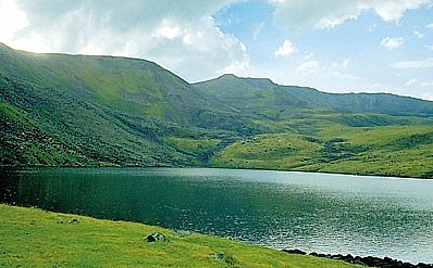
L E S S I N G L A K E I N T H E
M O U N T A I N S O F A R A G A T S
Whereas the Republic 's surface water resources are relatively meager, this cannot be said about its underground water resources. In some areas underground waters accumulate in abundance under crumbling and porous rocks under volcanic tuffs, basalt, sandstone, fine-textured slates and often in the very strata of these rocks. As it seeps through them the water purifies and then in many places comes to the surface in the form of clear springs. On seeing a solidified lava bed from afar one can be sure there are springs of delicious, cold water issuing from under it. The temperature of the water is usually 7-8 Cş all the year round. There are also acidulous springs which seethe with bubbles of different gases as well as many warm and even hot springs. These are mineral waters which, passing through the strata of easily soluble rocks- limestone, dolomites and magnetite-are enriched with salts and gases.
The mineral springs differ in their chemical composition and therefore ill their therapeutic properties.
Underground waters play an important role in Armenia's economy. The waters of the underground reservoirs with resources amounting to thousands of millions of cubic meters are used for irrigation and the water supply of the Republic together with those of the rivers, lakes and springs. Thus drinking water in the Ararat plain is also obtained from artesian wells.
The Republic numbers about 7, 500 fresh-water and 1,000 mineral springs. Most of the inhabited areas use cool spring water which is soft and pleasing to the taste. The yield of all the springs and artesian wells of the Republic amounts to about 100 cu m per second. However, they are distributed unevenly. In the basin of the Arax, where volcanic, filtering rocks predominate, there are many more springs than in the basin of the Kour with its sedimentary and almost impervious rocks. The largest groups of springs in Armenia are the Karasunakn ("Forty Springs") on the north-western slopes of the Gegham range, the springs on the eastern slopes of Aragats, and the Shaki Springs in the basin of the Vorotan river.
The commonest mineral springs contain bicarbonate or hydrocarbonate; others contain chlorides and carbonates, etc. North of Yerevan are the Arzni springs which contain alkaline carbonates. The waters of these springs are used in the treatment of cardiovascular and gastrointestinal diseases. Alkaline carbonate water of the Borzhomi type is contained in the springs near Dilizhan and Fioletovo, and springs of the Yessentuki type are found on the western shore of Lake Sevan, near the town of Gavar (Kamo). Notable among the thermal springs are the Dzhermuk springs whose temperature is 55-64 Cş; in its composition and therapeutic properties this water is similar to that of Karlovy Vary in Czechoslovakia. It is used in the treatment of diseases of the gastrointestinal tract, the musculo-skeletal system, the liver and diabetes. Yessentuki-type hot waters of Hankavan emerge in the valley of the Marmarik river.
Health resorts Arzni and Dzhermuk-have been built near the mineral springs; some of the water of these springs is bottled. The Arzni, Dzhermuk, Sevan and Dilizhan waters are excellent for drinking. Taken together, the mineral springs of the Republic yield more than 60 million litters of water a day. In addition to the water close on 1,500 tons of natural carbon dioxide can be annually obtained from these springs.